

15 years ago
Tuesday, 24 March 2009
Ministry Marathon
With our minds almost set on Alajo as the point of concentration we decided to make a ministry run to find out any relevant information on the same. We started the day with a fixed appointment with Mr. Joseph Ankra of NADMO (National Disaster Management Organization), which governmental organization dealing with disasters all over the nation. He briefed us on the structure and working of NADMO along with some basis ideas of disaster management and preparedness they undertake. He provided us with an emergency preparedness plan and suggested we talk to a colleague of his who is supposed to have further data that might be useful to us. With a meeting tentatively fixed in the coming week, we were advice to go to the Ministry of Transport Roads and Highways to get information on the road network and connectivity maps. From this point it was a day full of ministry meetings, started by all 3 barging into offices and asking for details. Bemused people sent us from floor to floor, building to building, department to department, ministry to ministry, everyone thinking the other will be a better door to knock at. Even though the day ended without much of information, we had a clear idea of the working of all the ministries and their inter-dependencies which we are sure will help us in the coming days to get some hard data.
Alajo at a stretch


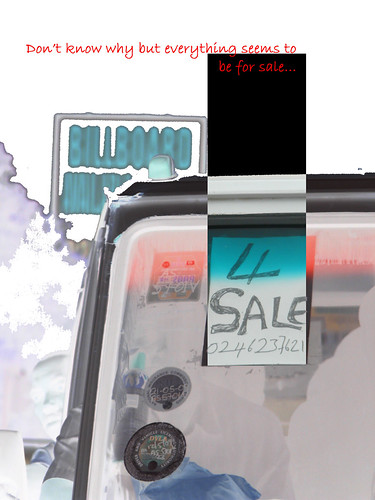
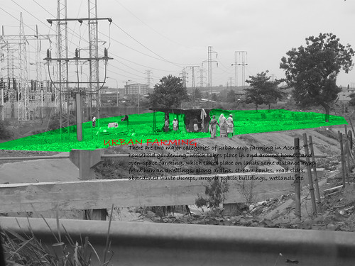
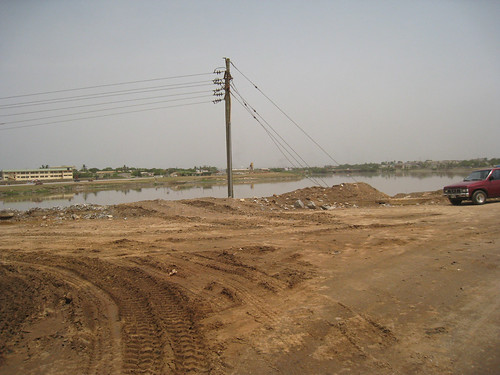
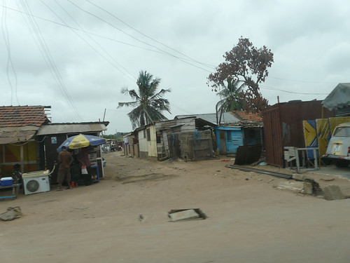
On a bid to select an appropriate site between the Lafa basin - Santa Maria and the Korle Basin –Alajo, we did a site visit to Alajo. We started with a quick walk on a bridge over the Korle Lagoon downstream the Odaw River passing through Alajo. The Entire city congested along the banks of the Odaw River dumps its waste into the same, which in turn empties its contents into the Korle lagoon passing it on to the sea. The Lagoon is filled with waste and black contaminated water, spreading an Omni-present stench. The banks of the lagoon are filled with solid waste and litter, marking an edge as waste fields. From here we made our way up north parallel the river passing through its banks on the western side. This part is now under serious activity for an ecological restoration project by the government to make the lagoon a green zone is the heart of the city. This restoration project seems to be a tall call owing the reason that the lagoon has been announced as an ecologically dead zone, and the whole river-lagoon system being the only main source of waste drainage for most of the city. Nevertheless the people in the government are quite sure of its possibilities. Then we reached Alajo, which is a low raise, lateral spreading old settlement which is mostly populated with temporary structures like Kiosks around solid buildings, sitting right on the banks of the Odow river. During rainy season swelling of the river caused huge flooding in the past as high as 1 to 1.5m as per local inhabitants, but as of now this problem seems to be solved by the dredging of the river and construction of a huge drain with concrete banks to retain the soil and to make huge spill ways for the flood water. We walked along the banks of the drain which is now the collection pit of all waste from the community making it a sewage drain. We went across the area cutting through small allies and sign boards put up by AMA marking in-appropriate built up structures. As it is in all places we went, we meet a lot of curious and friendly people who were ready to talk to us, answer our queries and greet us with great joy. Talking to them we found out that the flooding problem has been solved by the drain as of now. With certitude of clarity we start our analysis, with primary focus on past flood plains that have been rectified recently by the provision of huge open drains, which is leading to even more densification of the urban fabric, which may in future lead to the past problems.
Weekend at Fadome


Amidst the hectic search for site and constant brain storming we were invited by Mr. Wise for a weekend at his home town, Fadome in the Volta region, east of Ghana; which we accepted with at most delight. Then started a memorable day in Ghana, with a wake up at 3, to get ready by 4 in the morning, leading to a 5 hour tiring journey through exiting landscapes; then having a great homemade lunch at Wise’s place, before starting to a 600m high exhilarating waterfalls, which lead to a exhaustive mountain climb, extending forever, finally getting us to an enchanting bath. Last by not the least a tiring journey back home for a great dinner and a quite place to sleep. The next morning we got up at 6 and took a stroll through the village, seeing exited people and merry kids shouting obruni where ever we went. It was an important day for Fadome, when 8 of their chiefs and the paramount chief were going to meet in order to resolve their difference with the presence of UNDP and a lot of distinguished delegates. With another exhaustive mountain climb, this time the highest in West Africa we made it back to the ceremonial meeting almost at its final stages. With a lot of happy people dancing around we did our best to merge with the crowd, dancing around a group playing drums. Then fixing an appointment with Mr.Clever from UNDP we made our way back home having talks about the village and its various architectural aspects. The next day we had another early rise, this time at 4 to start back to Accra.
Quick Scan on Santa Maria


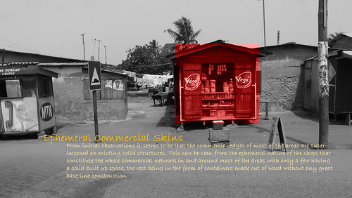
Based on the suggestions for an urban flood zone by Mr. Wise Valence, flood expert from the Hydrological Department, we visited the locality of Santa Maria on the western outskirts of Accra Metropolitan Authority (AMA). We landed up there like a bunch of travelers roaming around to find the lowest point of the mildly undulated landscape that seems to be completely covered with buildings. This is the new developing area of Accra which is spreading laterally on every piece of land available. It’s mostly residential settlements with a lot of small scale and cottage industries mainly focusing on building related activities like steel kiosk production, cell-Crete and paving tiles manufacture combined with a lot of service activities. We went along the main roads then branching onto side alleys following the water flow in the open drains. On the way we meet a couple of families who gave their perspective on flooding and the tentative water levels. It started with 60cm and went to the highest of 1.5m near a hospital. On quick enquiry this problem seems to be sorted out due to the construction of a drain right next to the hospital. Again the drain trail started following the main drain channel which finally lead us to a bigger stream of sludge that was a natural drain pattern of the area. With this identified as the lowest part we wonder if we found the site that suits our bill!!
Thursday, 12 March 2009
Our site, our neighborhood
We began the day with meetings, first with the director of the Geological Department and then with Wise Valence, flood expert from the Hydrological Department.
We inquired about their contacts, and its interesting to note that there does not seem to be a lot of connectivity between European/American NGOs and the local governmental organizations. I guess it is logical that these NGOs are not tied to the local government, but it seems like a missed opportunity, as the Hydrological Department, Disaster Expert Wise Valence, Town and Country Planning, and the National Survey Department have been key to our understanding of the flooding situation in Ghana.
Gabriela received a couple of wedding proposals and Arie became the center of attention a few times as we visited our new site, the Lafa Basin. It is beautiful and really low lying! Another bit of news... we happen to have moved inside the Lafa Basin, in the neighborhood of Dansoman. It only takes us about 20 minutes to walk to the salt pond, which means we are living in one of the most flood prone areas of Accra! We will show you the map of the basins in a few days. We asked about evacuation plans as well, which we will soon get from NADMO. The protocol is rather simple though: if you see hard rain coming then run to Odoko. Its really far for us though, so the we may just invest in a boat and some life jackets, especially since Shilesh does not know how to swim. He said he had problems at Tropicana. Ha! We will take care of him though, do not worry.
This weekend Wise has invited us to stay with him at his house in the Volta region. He offered to show us the tallest water fall in Africa and Afadjato mountain. It is going to be a real treat. We are also planning to meet with Simon, Environmental science PhD student from Univ. of Ghana, currently working for the EPA. Good excuse to go shopping for hiking boots and light-weight cotton clothes of local prints.

Animals for Disaster Waste Recovery ?!

Lafa Basin

Flood Affected House.

Lafa Basin
Tuesday, 10 March 2009
Videos of a funeral and other experiences
Funeral in Ghana
http://www.youtube.com/watch?v=LnKm4Mci8pU
Funeral in Ghana 2
http://www.youtube.com/watch?v=qTlzgdrFAc0
Driving through Ghana
http://www.youtube.com/watch?v=KIJr6Bur_64
Rain in Ghana
http://www.youtube.com/watch?v=LBQrUrJy_Nw
http://www.youtube.com/watch?v=LnKm4Mci8pU
Funeral in Ghana 2
http://www.youtube.com/watch?v=qTlzgdrFAc0
Driving through Ghana
http://www.youtube.com/watch?v=KIJr6Bur_64
Rain in Ghana
http://www.youtube.com/watch?v=LBQrUrJy_Nw
9 March: our own house!!
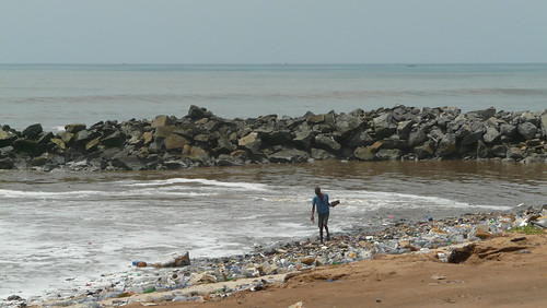
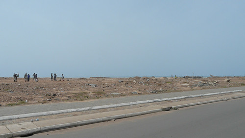
We begin the morning by preparing email and organizing photos. At 10 am, once the traffic become less busy, it is time for us to move to our house! We drive from the East side of Accra to the West, passing the Korley Lagoon. This is where the Odawna stream drains into the sea. The Odawna is responsible for flooding in Alajo, and is currently undergoing major rehabilitation. The smell is overwhelming and Frederick explains that unfortunately the river is used to drain much of the domestic wastes from the inhabitants that live along it. Lavander hills lies just on the other side of the lagoon, and is a major dumping site for sewage trucks in the sea. Frederick explains that there used to be a system in place that would treat waste before dumping it into the ocean, but that somewhere in the past the system broke down. We arrive to the house. It has 4 bedrooms, a living room, a dining room, a kitchen, and a terrace in the back. There are a few things missing, such as beds, fans and a working fridge, but the house is beautiful and spacious.
A 4th team member has joined the group. His name is Paapa. He is a student at the Methodist University in Accra and is doing his bachelor in Business Administration. These coming weeks he will help us with practical things to make our stay more pleasurable. Like becoming mad at the people who have to deliver the fans, which still have not arrived.
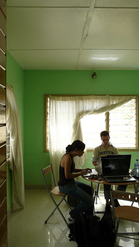
After a few minutes we convert the table and dining area to an office and begin making phone calls. Our first visit has been scheduled the same day with Regina Brown from the Geological Survey Department in ITC. By coincidence, her parents live right beside our new house. The meeting is short, but we take advantage to ask her some GIS questions, since we had experienced some problems opening files we had acquired from Richard (ITC). She is much better with GIS than we are. We explain to her the project, the back-story, and she seems very interested. We will meet with her again on Wednesday and she has offered to pick us up from the house in her car and take us to the office so we can meet with her colleagues and acquire a 2006 flood map. She is even kind enough to drop us off at the Internet cafe, where we wait again for 45 minutes this time for the power to come on.
Coast of Accra.
Coast of Accra
Korley Lagoon.
Working in our house.
Paapa and a man who is making our bed.
A 4th team member has joined the group. His name is Paapa. He is a student at the Methodist University in Accra and is doing his bachelor in Business Administration. These coming weeks he will help us with practical things to make our stay more pleasurable. Like becoming mad at the people who have to deliver the fans, which still have not arrived.
After a few minutes we convert the table and dining area to an office and begin making phone calls. Our first visit has been scheduled the same day with Regina Brown from the Geological Survey Department in ITC. By coincidence, her parents live right beside our new house. The meeting is short, but we take advantage to ask her some GIS questions, since we had experienced some problems opening files we had acquired from Richard (ITC). She is much better with GIS than we are. We explain to her the project, the back-story, and she seems very interested. We will meet with her again on Wednesday and she has offered to pick us up from the house in her car and take us to the office so we can meet with her colleagues and acquire a 2006 flood map. She is even kind enough to drop us off at the Internet cafe, where we wait again for 45 minutes this time for the power to come on.
Coast of Accra.
Coast of Accra
Korley Lagoon.
Working in our house.
Paapa and a man who is making our bed.
8 March: Funeral & Akosombo Dam
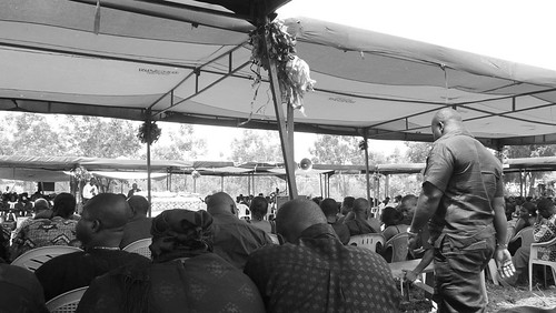
For our 3rd day in Ghana we are invited by Fred to experience a Ghanaian funeral in the village where his father used to live, Krobo Odumasi. After a ride of 60 km over smooth asphalt roads and humpy sand roads we arrive to the funeral, which had already started. First thing that appears is that there are much more people than on most Dutch funerals. During the funeral people are doing all kinds of things besides paying attention to the ceremony. There are people walking around, talking to each other, taking phone calls. At the end of the ceremony the coffin is carried away to the car, under the guidance of the youth band from the church.
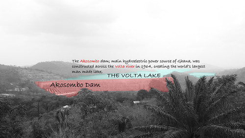
After this ceremony we drive further for another 2 hours to the Adomi bridge. This is the biggest bridge over the Volta River. The Volta River connects the Volta lake and the ocean. After stretching our legs and walking over the bridge we drive some more and accidentally take a wrong turn towards the east. We drive for what seems to be a long time, until Fred stops to ask a man walking beside the road with a big dead rat in his hand how to get to the Akosombo dam. Here we find out that we have to go back to the bridge. By then we have passed by the villages of Juapong, Frakadua, and almost reached the capital of the Volta region, Ho. After a 15 minutes drive from the bridge we finally arrive to the Akosombo Dam. This dam was inaugurated by Nkrumah in 1966 and is Ghana’s largest dam. The Akosombo Dam created the most expansive artificial lake in the world with a surface area of 850.000ha. It is one of the main causes of flooding in the north of Ghana, but also responsible for supplying water and electricity to the country.
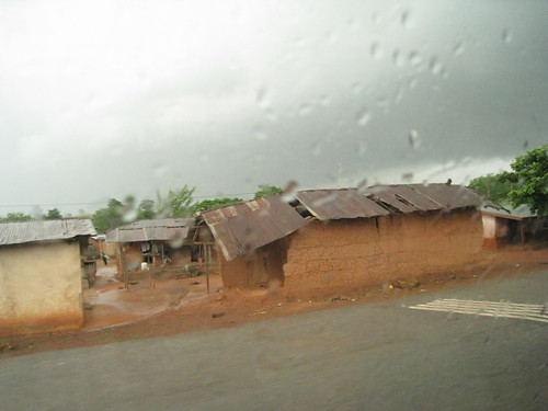
On our way back we experience our first tropical rain. It starts with a gray sky. Then the sky becomes darker and the wind heavier until big drops start falling out of the sky. People who were selling stuff on the side of the road quickly gather there things under a roof. Between the houses the water started to collect and search for the lowest areas creating little flows. The rain becomes heavier and the roads started to flood. It even starts to get cold. We stop for dinner at a restaurant that Frederick recommends, and Gabriela tries fufu for the first time. It tastes really good, but the gooey texture of the yams is a bit unexpected. We watch the game in the meantime. The rain has almost stopped by then and we head back to Accra. Now the rain stopped, people are setting up there business and the streets become crowded again.
In the evening we come home to a dark house, because the electricity has gone out.
We end the day talking with Nana Kwame. He is the nephew of Leticia and staying over for the weekend with his aunt. Nana is a student at the Cape Coast University and studies Mathematics and Economics. He helps us to gain some insight into the economical situation in Ghana.
Funeral
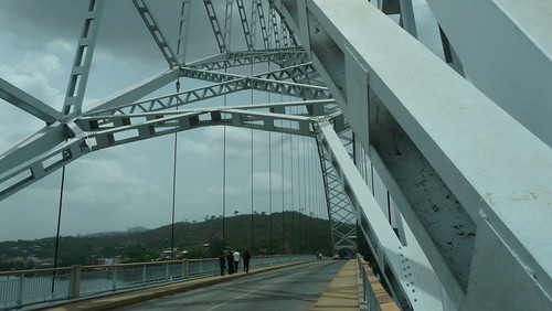
Volta bridge.
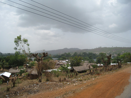
Community aside the Volta river.
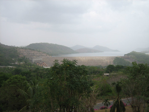
Akosombo Dam
Our first Rain in Ghana.
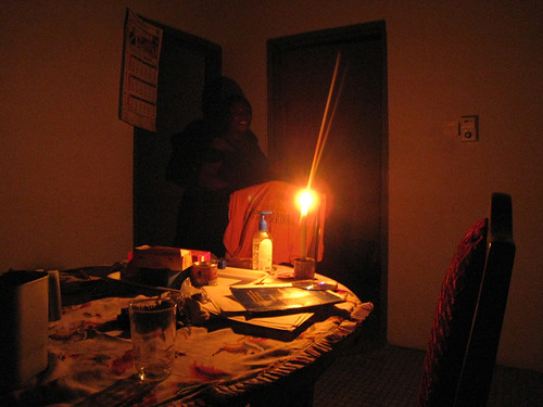
Evening without electricity.
After this ceremony we drive further for another 2 hours to the Adomi bridge. This is the biggest bridge over the Volta River. The Volta River connects the Volta lake and the ocean. After stretching our legs and walking over the bridge we drive some more and accidentally take a wrong turn towards the east. We drive for what seems to be a long time, until Fred stops to ask a man walking beside the road with a big dead rat in his hand how to get to the Akosombo dam. Here we find out that we have to go back to the bridge. By then we have passed by the villages of Juapong, Frakadua, and almost reached the capital of the Volta region, Ho. After a 15 minutes drive from the bridge we finally arrive to the Akosombo Dam. This dam was inaugurated by Nkrumah in 1966 and is Ghana’s largest dam. The Akosombo Dam created the most expansive artificial lake in the world with a surface area of 850.000ha. It is one of the main causes of flooding in the north of Ghana, but also responsible for supplying water and electricity to the country.
On our way back we experience our first tropical rain. It starts with a gray sky. Then the sky becomes darker and the wind heavier until big drops start falling out of the sky. People who were selling stuff on the side of the road quickly gather there things under a roof. Between the houses the water started to collect and search for the lowest areas creating little flows. The rain becomes heavier and the roads started to flood. It even starts to get cold. We stop for dinner at a restaurant that Frederick recommends, and Gabriela tries fufu for the first time. It tastes really good, but the gooey texture of the yams is a bit unexpected. We watch the game in the meantime. The rain has almost stopped by then and we head back to Accra. Now the rain stopped, people are setting up there business and the streets become crowded again.
In the evening we come home to a dark house, because the electricity has gone out.
We end the day talking with Nana Kwame. He is the nephew of Leticia and staying over for the weekend with his aunt. Nana is a student at the Cape Coast University and studies Mathematics and Economics. He helps us to gain some insight into the economical situation in Ghana.
Funeral
Volta bridge.
Community aside the Volta river.
Akosombo Dam
Our first Rain in Ghana.
Evening without electricity.
7 March
The second day we spend organizing the photos and discussing the project. After having a typical Ghanaian lunch made by Leticia we go to an internet café. A sign on the wall reads that it is not allowed to use the internet for porn and 419. After asking Fred we found out that 419 is used as a code for criminality. We loose power a couple of times, but it turns back on after a few minutes. This was for Shilesh directly a hard lesson, because he had not save the email he was writing. After the generator is turned on we continue and this time saving every minute.
When walking back from the internet café we decide to walk over a market which we were passing.
After we come back, a vistor stops by to visty Frederick, but because Fred is not home we take advantage to ask him some questions. Harry works for the Port Authority, but also has some insight into the flooding problems of Accra. He tells us that the flooding in Accra is a combined problem. For one, the drainage system gets clogged easily, then the open drains swell up and flood during heavy rainfall.
6 March: independence day.
In the morning we experience typical unreliability with the water system. Frederick tells us that, often times the water will cut off, so we have to shower using a small bucket or a cup. This reminds Gabriela of her time in Venezuela. For Manuela it is a nice experience to have ‘obruni’ people in the house. She gets her friends next door to come by and show off her guests. Arie is especially exotic for them. All in all, we are greeted with curiosity and great hospitality.
It is interesting because we happened to arrive to Accra on Independence Day, and were able to celebrate the prime minister, Nkrumah's, declaration of the former Gold Coast colony as an independent nation on the 6 March 1957. We watch the independence parade that morning on television.
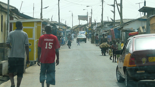
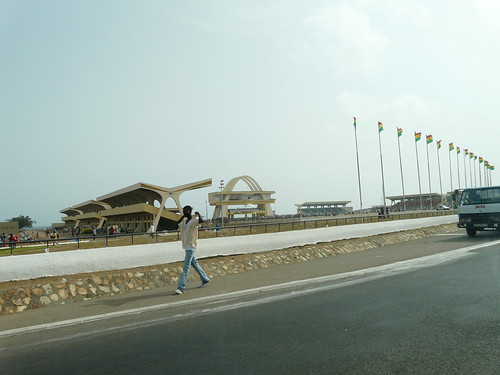
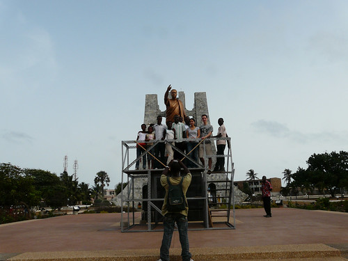
In the afternoon Fred gives us a driving tour of the different parts of Accra, first hitting the rough spots and then the not so rough places. We see the neighborhood of Teshie, an informal community, which sprang up without planning. Frederick works for the Town and Country Planning Department in Accra, so it is interesting to see the city through his perspective. He explains the challenges of providing adequate plumbing, sanitation, and electricity infrastructure in these types of settlements. The lack of infrastructure also has an effect on the city's density, which does not support high rises. He says that the tallest building in Accra is about 15 stories. Most of the unplanned settlements are single or two story houses. After Teshie we drive through a military zone and then pass the independence square where the ceremony has already ended. We stop at the Kwame Nkrumah Memorial Park. In the middle of the park stands a tomb where Nkrumah has been buried. In front of the tomb is the podium where Nkrumah officially declared the independence of Ghana. This podium is still accessible and many people stand on the podium themselves to take a picture. We are invited to join the picture of another group. It is not difficult to make friends in Ghana! We also visit the museum. After this we continue our trip to Alajo, one of our sites of focus. From Alajo we drive to Dzorwulu which is the richer and more expensive part of Accra.
During this trip Fred gives us some insight into the city's problems and how they occur. The problem of flooding in Accra has different actors and agents. The rivers through Accra are losing space to people who are building along them, in the flood prone riverbanks. It is a complex situation that we are just beginning to grasp.
Teshie.
Independence square.
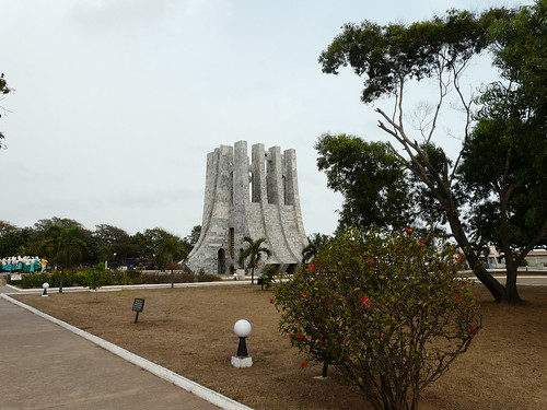
Kwame Nkrumah Memorial Park
Podium in front of the tomb.
Alajo
It is interesting because we happened to arrive to Accra on Independence Day, and were able to celebrate the prime minister, Nkrumah's, declaration of the former Gold Coast colony as an independent nation on the 6 March 1957. We watch the independence parade that morning on television.
In the afternoon Fred gives us a driving tour of the different parts of Accra, first hitting the rough spots and then the not so rough places. We see the neighborhood of Teshie, an informal community, which sprang up without planning. Frederick works for the Town and Country Planning Department in Accra, so it is interesting to see the city through his perspective. He explains the challenges of providing adequate plumbing, sanitation, and electricity infrastructure in these types of settlements. The lack of infrastructure also has an effect on the city's density, which does not support high rises. He says that the tallest building in Accra is about 15 stories. Most of the unplanned settlements are single or two story houses. After Teshie we drive through a military zone and then pass the independence square where the ceremony has already ended. We stop at the Kwame Nkrumah Memorial Park. In the middle of the park stands a tomb where Nkrumah has been buried. In front of the tomb is the podium where Nkrumah officially declared the independence of Ghana. This podium is still accessible and many people stand on the podium themselves to take a picture. We are invited to join the picture of another group. It is not difficult to make friends in Ghana! We also visit the museum. After this we continue our trip to Alajo, one of our sites of focus. From Alajo we drive to Dzorwulu which is the richer and more expensive part of Accra.
During this trip Fred gives us some insight into the city's problems and how they occur. The problem of flooding in Accra has different actors and agents. The rivers through Accra are losing space to people who are building along them, in the flood prone riverbanks. It is a complex situation that we are just beginning to grasp.
Teshie.
Independence square.
Kwame Nkrumah Memorial Park
Podium in front of the tomb.
Alajo
Arrival in Accra
After a 14 hour trip, with a 6 hour stopover in Casablanca, we arrive at 4 am at the Kotoka international airport in Accra. At the customs counter we receive a visa stamp for 60 days, instead of the 3 months we had originally been granted from the embassy in the NL. The customs official offers to let us buy the additional month for 100 euro, which we of course do not accept. Fortunately, Frederick is waiting for us outside the airport. He finds us before we even have a chance to call him. We are such an eclectic group; it must not have been difficult for him to guess. There are many young Ghanains waiting outside to help us with our luggage, we notice this cool snapping thing they did with their fingers at the end of a hand shake. I remember thinking they are friends of Frederick, but later discover that Frederick does not know them at all. We ride in the car piled high with luggage on our laps, but once we are 'safe' we stop and put the luggage in the back of the truck. Fred explains to us that sometimes bags go missing when you do not pay attention. Frederick is one of the contacts we met through a pastor named Samson, who knows Armstrong, who works with Trude at Enviu. He lives just outside Accra with his wife Leticia and daughter Manuela.

Mohammed V airport, Casablanca.

The house of Fred.


Mohammed V airport, Casablanca.
The house of Fred.

Nana Kwame, Leticia, Fredrick.

Manuela
Monday, 2 March 2009
Subscribe to:
Posts (Atom)